...... A quick inspection of the publications listed at the bottom of this page, which are attributed to John Seller Sr., or to which he has contributed, will reveal that John Sellers was not only an instrument maker, surveyor, cartographer, artist and Hydrographer to the King, but more over he was responsible for the first English Pilots. Pilots which were continually reprinted and still in use centuries after his death in 1697. Library records show that one of his first publications was entitled:
"Practical navigation: or, An introduction to that whole art. Containing I. Several definitions in geometry, astronomy, geography, and navigation. 2. A new and exact kalender, etc."
He produced Charts and Atlases, Navigational aids, almanacs, celestial maps, as well as Pilots, and should perhaps be remembered first and foremost for his major contribution to the Maritime world of sailing and Navigation.
John Seller Sr.
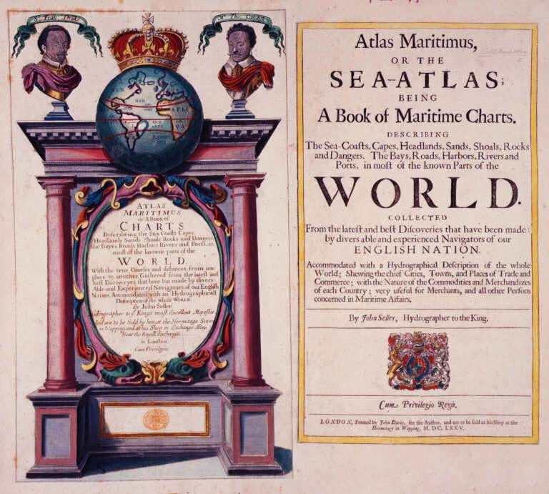
The 'Atlas Maritimus'
By Ashley Baynton-Williams
John Seller Sr. (d.1697) is one of the most important figures in the early history of the map and chart-publishing trade in England. He was the first Englishman to try establish an atlas-publishing business comparable with Continental firms, such as Blaeu, Jansson, de Wit, Goos, Colom & Doncker.
No other London publisher of his day offered the variety of stock that Seller sold. In folio form he published a celestial atlas, two terrestrial atlases, a sea-atlas, several coasting pilots, as well as a large number of separately-issued charts. In addition, he also published number of navigation handbooks, almanacs, pocket books, miniature sea-atlases, and made a variety of mathematical and navigational instruments and tools.
Unfortunately his efforts were built on shaky foundations and were ultimately unsuccessful. For much of his business life Seller walked a narrow line between solvency and bankruptcy. In 1677 bankruptcy was averted only by Seller entering into partnership with a consortium of interested parties, principally William Fisher, a leading printer and seller of navigation books, and John Thornton, a noted manuscript chartmaker who was beginning to make the successful transition into the printed chart trade. While one explanation of this is Seller's own lack of business acumen, his career also emphasises that the domestic market in Britain for printed maps and atlases was simply too small to absorb the output of an active and innovative publisher. Seller's failed to marshal his limited resources and direct them into one project at a time. Instead he endeavoured to produce too many divers atlases and pilots at one time and did none of them particularly well
Seller paid a heavy price for the rescue by Thornton and Fisher. When the partnership was dissolved in 1679, Fisher retained the publishing rights for Seller's two main sea-atlases, English Pilot for the Southern Navigation and the Atlas Maritimus, and also took several map-plates and some of the stock of printed sheets. Thornton received some of Seller's stock of printing plates.
Seller made one last effort to restore his business, planning an ambitious county atlas from new surveys: this project also foundered, and thereafter he remained a small-time player, while his former partners expanded and prospered.
Seller's principal folio atlas, and the one most frequently encountered today, was the Atlas Maritimus, first published in 1675. This sea-atlas was completely composite in make-up, being assembled according to the wish of the individual purchaser rather than to a standard format, although built round a standard core. Accordingly, the content can vary considerably. The example being described is among the largest of such collections that I have seen, and is noteworthy for the way Seller had combined charts from the Atlas Maritimus of Frederick de Wit, published circa 1675, with his own, to make a total of forty-three charts.
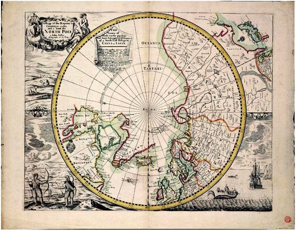
Among the most interesting of the Seller charts are the group of astronomical charts and the map of the North Pole, which were prepared in 1676 or 1677, and so are found only in late examples of the atlas.
The example of the atlas described was dispersed in separate sheets, or lots, at two auctions in London. At the time an attempt was made to acquire all the Seller charts, to reconstitute the Seller element for a collector. Unfortunately, while all the charts from the first sale were purchased, three of the most valuable, all already present in the client's collection, proved evasive. After the sale, the letterpress titlepage was purchased from the vendors, who retained the engraved title, although it was photographed at the time.
The atlas now forms part of the Lawrence Slaughter Collection, in the New York Public Library's Map Division.
http://www.mapforum.com/06/seller1.htm.
JOHN SELLER [ca. 1630-1697]
John Seller's shop, located near the Tower of London in Wapping, an insalubrious and noisy sailors' neighborhood on the north shore of the Thames. In the local pubs and coffeehouses, crews arriving in Wapping with the latest news of distant places such as the West Indies exchanged information with other sailors, mapmakers, and ships' suppliers, and provided Seller with information critical to his nautical chart business. Seller's mapmaking shop became a center of nautical learning, offering lessons in "Arithmetick, geometry, algebra, trigonometry, navigation, and gunnery; likewise the use of the globes, and other mathematical instruments, the projection of the sphere, and other parts of the mathematics."
Although as a Baptist and nonconformist Seller was found guilty of conspiring to kill King Charles II, he was reprieved, possibly at the behest of the King's brother James, the Duke of York. Ironically, Seller was appointed Hydrographer by Charles II in 1671, and also served under James II and William III. As the King's Hydrographer, Seller was granted a 30-year privilege giving him a monopoly on publishing nautical atlases in England. Over his long career, Seller published a variety of titles, often in numerous editions, such as Praxis Nautica, or Practical Navigation (1669); Atlas Maritimus (1669); An epitome of the art of navigation (1681); and Atlas Terrestris (1676). While his maps often lack beauty and finesse, Seller contributed significantly to English cartography by helping to establish the market for English-language maps and charts and encouraging the growth of the cartographic industry in 17th-century England.
http://www.nypl.org/research/chss/epo/mapexhib/seller.html.
John Seller

A Mapp of New England, ca.1675
John Seller was a pioneering British publisher of nautical charts. He bore the impressive title "Hydrographer in Ordinary" to the king.
Seller's map of New England, which was first published sometime between 1666 and 1674, is the first printed British map of the New York area not entirely dependent on Dutch prototypes. It is derived from a variety of British and Dutch sources. Parts of the map (including the illustrations of animals) are clearly copied from maps like the Blaeu and Visscher maps described above. The depiction of the Hudson Valley is less accurate than on the best contemporary Dutch maps, but Long Island shows a number of features that do not appear on any previous printed maps. Much of this information is derived from an unpublished map of New England by John Scott, who pursued a controversial political career on Long Island before being forced to flee to England.
Like many early maps, Seller's chart of New England exists in several different "states," which were usually created by altering the copper plate on which a map was engraved. This version appeared in Seller's Atlas Maritimus, or the Sea-Atlas, which was first published in 1675
REFERENCES:
David Yehling Allen, Long Island Maps and Their Makers , 12-16
William P. Cumming, British Maps of Colonial America , 38-39
http://www.sunysb.edu/libmap/Seller.htm.
Publications - Maps
from 'COPAC v.3 Brief Records' of the Victoria University of Manchester
1665 - Atlas terrestris: or, A book of mapps, of all the empires, monarchies, kingdomes, regions, dominions, principalities, and countreys in the whole world : accomodated with a brief description of the nature and quality of each particular countrey / By Iohn Seller, hydrographer to the Kings most excellent majestie.
1669 - Practical navigation: or, An introduction to that whole art. Containing I. Several definitions in geometry, astronomy, geography, and navigation. 2. A new and exact kalender, etc. / [by] Seller, John, Hydrographer.
1670 - Atlas Minimus, or a Book of Geography, shewing all the Empires, Monarchies, Kingdoms ... and Countries in the whole World. By John Seller, etc. (A Geographical Description of the World. pp. 48) / [by] Seller, John.
1670 - Novissima et Accuratissima XVII Provinciarum Germaniae Inferioris Delineatio / ex officina Iohannis Selleri.
1670 - A Mapp of the Seat of the Warrs in Germany and the Spanish Netherlands ... by J. Seller. King sculp / [by] King, Daniel ; Seller, John.
1670 - A Mapp of the Seat of the Warrs in Germany and the Spanish Netherlands ... by J. Seller / [by] King, Daniel ; Seller, John.
1670 - Atlas Maritimus or a Book of Charts ... by J. Seller / [by] Seller, John.
1670 - The coasting pilot : describing the sea-coasts of England, Holland, Flanders, and France / published by J. Seller.
1671 - A Description of the Sea Coasts of Coerland and Lyfland, etc / [by] Seller, John.
1671 - A Chart of part of Norway and Lapland, describing the Sea Coasts between the North Cape and the mouth of the White Sea / [by] Seller, John.
1671 - A Chart of the Coast of Norway between the Naze and Bergen, etc / [by] Seller, John.
1671 - A Chart of the North Part of America; describing the Sea Coast of ... Davies Streights, etc / [by] Seller, John.
1671 - A Chart of Norway between Stemnes-hest and the Citty of Dronten, etc / [by] Seller, John.
1671- A Chart of the North Sea. By J. Seller / [by] Beers, F. W. ; Seller, John.
1671 - A Large Description of the two Channels [sic] in the River Dwina goeing [sic] up to the Citty of Archangel / [by] Seller, John.
1671 - A Chart of the Eemes, Elve, etc / [by] Seller, John.
1671 - A Chart of the Eemes as the Easter and Wester Eemes, Scholbalgh and the Lauwers / [by] Beers, F. W. ; Seller, John.
1671 - A Chart of the Eemes, Elve, Amelander Gat, Lauwers, Scholbalgh, the Weser, Eyder and Hever and how the same doth bare from Holy Land / [by] Beers, F. W. ; Seller, John.
1671 - A Description of the Sea Coasts of Normandy and Bretaigne between Cape de Hague, Ushant, and the Seames, etc / [by] Seller, John.
1671 - A Chart shewing the Sea Coasts of the Bellt [sic], Wedersound, Melversound, with all the adjacent Islands / [by] Seller, John.
1671 - A Description of the Sea Coasts of the Souther part of the Belt, also Meklenburg, Pomerland, etc / [by] Seller, John.
1671 - A Chart of the Sea Coasts of Schoonen, Zeeland, etc. [i.e. the Sound] / [by] Seller, John.
1671 - A Chart of the Sea Coast of Biscay ... between Cape Machicaca and Cape de Pinas / [by] Seller, John.
1671 - A Chart of the Sea Coasts of Schoonen ... Newly corrected by John Seller ... A scale of English leagues, 9[ = 100 mm] / [by] Seller, John.
1671 - A Chart of the Chanell of Bristoll [sic] from Silly to St. David's Head in Wales, etc / [by] Seller, John.
1671 - A Chart of the Islands of Shotland [sic] / [by] Seller, John.
1671 - Description of the East Coast of Scotland / [by] Beers, F. W. ; Seller, John.
1671 - A Draught of the Island [of] Buss ... Island Oliver fe / [by] Seller, John.
1671 - A Chart of the North Part of America, describing the Sea Coast of ... Buttons Bay, etc / [by] Seller, John.
1671 - The Hauen of Saint Malo / [by] Seller, John.
1671 - Ollonne in France / [by] Seller, John.
1671 - A Description of the Sea Coasts of Coerland and Lyfland, etc / [by] Seller, John.
1671 - A Chart and Description of the Canary Islands, With all the Roads and Havens in each of them / [by] Seller, John.
1671 - A Chart of the Sea Coast of Portugall between the Burlings and Cape de St. Vincent / [by] Seller, John.
1671 - A Chart of the Sea Coasts of Russia, Lapland, Finmarke, Nova Zembla, etc / [by] Seller, John.
1671 - A Descriptio of the Coast of Norway between the Paternosters and the Naze, etc / [by] Seller, John.
1671 - A Description of the Coast of Norway between Bergen and Stemnes-hest, etc / [by] Seller, John.
1671 - A Chart of the Northermost part of Norway from the Citty of Dronten to the North Cape, etc / [by] Seller.
1671 - A Description of the Sea Coasts of ... France ... from Callice [sic] to the Casquets / [by] Seller, John.
1671 - A Description of the Sea Coast of France from Olone to Bayone in Biscay and part of that Coast thence to Cape [S. Andero in Santander] / [by] Seller, John.
1671 - A Chart of the Sea-Coasts of Galisia [sic] between Cape de Pinas and Cape Finister / [by] Seller, John.
1671 - A Chart of part of the Sea-Coasts of Gallisia [sic] and Portugall betweene Cape de Finisterre and the Burlings, etc / [by] Seller, John.
1671 - A Chart of y? Narrow Seas newly corrected by John Seller ... English leagues, 50[ = 110 mm] / [by] Beers, F. W. ; Seller, John.
1671 - The Coasting Pilot: describing the Sea coasts ... of England, Flanders and Holland ... with new draughts and descriptions [for the navigation of the Thames from London Bridge to Hopeness and the S. Coast of England to the Scilly Isles.] Collected and published by J. Seller. pp. 54 / [by] Beers, F. W. ; Seller, John.
1671 - A Chart of Greenland ... Cherry Island and Hope Island, by J. Seller ... English leagues, [10 = 20 mm] / [by] Seller, John.
1671 - A Chart of the Hebrides lying on the North-west point of Scotlad / [by] Seller, John.
1671 - The Coast of Holland between the Maes and the Texel / [by] Beers, F. W. ; Seller, John.
1671 - A Chart of the Coast of America from New found Land to Cape Cod / [by] Seller, John.
1671 - A Chart of the North Part of America, describing the Sea Coast of Groenland, Davies Streights, Baffins Bay, Hudson's Streights, Buttons Bay and James Bay / [by] Seller, John.
1671 - A Chart of the Coast of Sweden, Bornholm, Oeland, Gotland, with all the rest of the adjacent Islands, from Falsterbon to Stockholm / [by] Seller, John.
1671 - A chart of the Fly and Amelander Gat / [by] Beers, F. W. ; Seller, John.
1671 - The English Pilot. The first book. Describing the ... Northern Navigation ... (The second book. Describing the Southern Navigation.-The third book. Describing the Oriental Navigation.) Collected ... by John Seller. Also an appendix, containing a ... description of the ... Coast of England ... by Capt. Gilb. Crane, and Capt. Tho. Brown ... The sea-coasts surveyed, by Jonas Moor. / [by] Seller, John, Hydrographer.
1671 - A Chart of the White Sea, shewing all the true description of the Sea Coasts, Islands, Rivers, Bayes, Roads, and Harbors, from Knock John to the Coast of Corelia / [by] Seller, John.
1671 - A General Chart of the West India's / [by] Keulen, Gerard van , et al.
1671 - A Chart of the Weser and Jade / [by] Seller, John.
1671 - A Chart of the Coasts of Barbarie ... from C. Vincent to C. Verd / [by] Seller, John.
A Description of the Coast of Barbarie between Cape de Cantin and Cape de Geer / [by] Seller, John.
1671 - A Description of the Coast of Barbarie from Cape Spartell to Cape Cantin, etc / [by] Seller, John.
1671 - A Chart of the Fly and Amelander Gat / [by] Beers, F. W. ; Seller, John.
1671 - The River of Tyne / [by] Beers, F. W. ; Seller, John.
1671 - A Chart of the Gat of Abbo or Uttoy / [by] Seller, John.
1671 - The River of Thames from London Bridge to Tilbury hope / [by] Seller, John.
1671 - A Chart of Spaine, particularly discribing the Coasts of Biscaia, Gallissia [sic], Portugal, Andaluzia, Granada, etc / [by] D'Ostening, H. von ; Seller, John.
1671 - A Chart of Greenland [i.e. Spitzbergen], Cherry Island and Hope Island / [by] Seller, John.
1671 - A Chart of the Sea Coasts of Russia, Lapland, Finmarke, Nova Zemla and Greenland [i.e. Spitzbergen] / [by] Seller, John.
1671 - A Chart of part of the Baltick Sea between Borneholm, and Der Memel, etc / [by] Seller, John.
1671 - A description of the sands, shoals, buoyes, beacons, roads, channels, and sea marks, on the coast of England : From the Southforeland, to Flamborough head, being furnished with new & exact draughts of the sands, acording to the said descriptions / By John Seller, hydrographer to the Kings most excellent majestie.
1671 - The coasting pilot : Describing the sea-coasts, channels, soundings, sands, shoals, rocks, & dangers: the bayes, roads, harbours, rivers, ports, buoyes, beacons, and sea-marks, upon the coasts of England Flanders and Holland with directions to bring a shipp into any harbour on the said coasts. Being furnished with the new draughts, charts, and descriptions, gathered from ye experience and practise of diverse able and expert navigators of our English nation / Collected and published by John Seller. Hydrographer in ordinary to the King.
1671 - A Chart of the Baltick Sea with the North Bodom and Lading / [by] Seller, John.
1671 - A Chart of the Nort Part of America, describing the Sea Coast of ... Baffins Bay, etc / [by] Seller, John.
1671 - The English pilot / collected ... by J. Seller. The first book, Describing the sea-coasts ... in the whole northern navigation [& in the southern navigation].
1671 - A Chart of the Northerne Sea, from England Westerly as farr [sic] as New Found Land and Notherly as farr as Island Groenland and Fretum Davis. By J. Seller, etc / [by] Seller, John.
1671 - A Generall Chart of the Northerne Navigation / [by] Seller, John
1671 - Charles R. [A proclamation, directed against unauthorised reprints of J. Sellar's "English Pilot" and "Sea Atlas."] [22 March, 1671.] B.L. / [by] ENGLAND ; Seller, John, Hydrographer.
1761 - A Chart of the Sea Coasts of Russia, Lapland, Finmarke, Nova Zemla and Greenland [i.e. Spitzbergen] / [by] Seller, John.
1671 - A Chart of the South Sea, Texel and Fly-streame, etc / [by] Beers, F. W. ; Seller, John.
1672 - A Chart of the sands, shoals, buoys, beacons and sea marks upon the Coast of England [from Folkestone to Skegness] / [by] Oliver, John ; Seller, John.
1672 - A description of the East Coast of Scotland, shewing all the beyes, roads, havens, harbours, depths, and soundings, courses & distances of places on the said coasts / newly corrected and published by John Seller.
1672 - The coasting pilot : describing the sea-coasts... of England, Flanders and Holland / corrected & published by J. Seller.
1673 - A Draught of the Land's End of England and Islands of Silly / [by] Seller, John.
1673 - A Chart of the Maes and Wielingen, showing the Channell of Brewers haven, Zierick and Viergat / [by] Seller, John.
1673 - The Coast of Bretaigne and Poictou, between ye Seames and St.Martin's Island, etc / [by] Seller, John.
1673 - The Coast of Holland between the Maes and the Texel / [by] Seller, John.
1673 - A Chart of the part of England and part of Scotland [from Ingoldmells Point to the Orkneys] / [by] Seller, John.
1673 - A Mapp of the French conquests in the Netherlands in the years 1672 & 1673 & also shewing their marches into Germany with a plaine representation of y? Cityes, Townes and Fortifications in those countryes, by John Seller. T. Burnford sc. A scale of English miles, 60[ = 95 mm.] (A Relation of the French conquests in the Netherlands, in 1672 and 1673) / [by] Burnford, Thomas ; Seller, John.
1673 - The Coasting Pilot, describing the ... Coasts of England, Flanders, and Holland, etc. / [by] Seller, John, Hydrographer.
1673 - A Chart of Flanders between Calis and Walcheren, with all ye sands and shoals upon that coast / [by] Seller, John.
1673 - The Coasting Pilot: describing the Sea-Coasts ... of England, Holland, Flanders & France. Collected and published by John Seller. pp. 52 / [by] Seller, John.
1673 - A Chart of the Brittish Chanel [sic] / [by] Seller, John.
1673 - A Draught of the Narrows. Describing the New Channel between the Spell and Last [Sands]. Surveyed by the Trinity House / [by] Seller, John.
1674 - A Mapp of the XVII. Provinces and the adjacent countreyes wherein is the present Seat of the warr in the year 1674. By John Seller ... T. Burnford sc. A scale of English miles, 60[ = 95 mm.]. (A Description of the Seventeen Provinces; shewing the nature and quality of each Province; the principal cities, and fortifications) / [by] Burnford, Thomas ; Seller, John.
1675 - Novissima totius Terrarum Orbis tabula. Auctore Joh: Seller / [by] Hollar, Wenceslaus ; Seller, John ; Thornton, John.
1675 - A Chart of the Sea coasts [of Europe and Africa] from the Landsend of England to Cape Bona Esperanca. [With the arms of, and dedication to the Royal African Company of England] / [by] Seller, John.
1675 - The Coasts of England and France from Arundel to the Start and from Cape de Barfleur to I. de Bass / [by] Seller, John.
1675 - The Coasts of England and France from Dover to the Isle of Wight, and from Calice [sic] to Cape de Hague / [by] Seller, John.
1675 - A Chart of the Sea-coast of Zealand from Walcheren to the Maes. [Scale,] 5 English ... leagues[ = 150 mm.]. Ia Clark sculp / [by] Seller, John.
1675 - Atlas Maritimus, or the Sea-Atlas; being a book of maritime charts, describing the sea-coasts, capes, headlands ... in most of the known parts of the World, etc. / [by] Seller, John, Hydrographe.
1675 - A Mapp of the Seat of the Warrs in Germany and the Spanish Netherlands, .. by J. Seller / [by] King, Daniel ; Seller, John.
1675 - A Chart of the Coast of England and Scotland [from Ingoldmells Point to the Orkneys] / [by] Oliver, John ; Seller, John.
1675 - A Mapp containing the Island & Kingdoms of Sicily ... W. Hollar fecit, 1676. (Prospect of the Straights of Sicily, vulgarly caldt Faro di Messina, from the North) / [by] Seller, John.
1675 - A Mapp containing the Island and Kingdome of Sicily ... & particularly the Citty & Fire of Messina, both Prospect and Groundplat, etc. W. Hollar fecit, 1676. (Messina) / [by] Hollar, Wenceslaus ; Seller, John.
1675 - A Chart of the North Sea. By J. Seller / [by] Seller, John.
1675 - A Mapp of the Two Hemispheres of the Heavens / [by] Seller, John.
1675 - A Chart of the Westermost part of the Mediterranean Sea / [by] Hollar, Wenceslaus ; Seller, John.
1675 - A Mapp of the Regions & Countreyes under and a bout the North Pole. By Iohn Seller, Hydrographer to the King. The Names of those worthy persons that have attempted ??y discouery of a North East Passage to China and Japan. [From 1550 to 1676.] Coloured / [by] Seller, John.
1675 - A Chart of the Western Ocean / [by] Seller, John.
1675 - A Mapp containing the Island & Kingdome of Sicily with a part of Naples, and other adjacent Coasts including the Tyrrhencan Sea, where most of things betwixt Spaine & France & their Alyes are acted, very comodiovsly contrived for y? present juncture of affaires, & particularly the Citty & Fire of Messina, both Prospect and Groundplat, etc. W. Hollar fecit, 1676. Scale of Italian miles, 100[ = 48 mm.]. (Prospect of the Straights of Sicily, vulgarly calldt Faro di Messina, from the North. Messina) / [by] Hollar, Wenceslaus ; Seller, John.
1675 - Novissima et Accuratissima Insulae Jamaicae Descriptio, per Johannem Sellerum ... A Catalogue of the severall Precincts ... Scala Milliarium Anglicorum, 40[ = 120 mm] / [by] Seller, John.
1675 - A Chart of the Tartarian Sea from Nova Zemla to Japan / [by] Oliver, John ; Seller, John.
1675 - A Chart of the Sea Coast of Brazil, from Cape St. Augustine to the Straights of Magellan / [by] Oliver, John ; Seller, John.
1675 - A Mapp of the Citie and Port of Tripoli in Barbary. W. Hollar fecit, 1675 / [by] Seller, John.
1675 - A Chart of the Bay of Biscaia / [by] Oliver, John ; Seller, John.
1675 - The English pilot / by J. Seller. The third book. Describing the... Oriental navigation.
1675 - A Chart of the two Channels goeing [sic] into the Baltique Sea, one through the Catte Gat and the Sound and the other through the Belt / [by] Oliver, John ; Seller, John.
1675 - The Coasts of England and France from Dover to the Isle of Wight and from Calice [sic] to Cape de Hague / [by] Seller, John.
1675 - The English Pilot: describing the sea-coasts ... harbors, rivers and ports in the Northern and Southern Navigation ... Being furnished with new and exact draughts, charts, and descriptions ... Collected by Iohn Seller. (The first Book. Describing the sea-coasts ... in the whole Northern Navigation ... Divided into three parts. pp. 124.-- The second Book. [Southern Navigation. Divided into three parts.] pp. 80) / [by] Seller, John.
1675 - The Coasts of England and France from Arundel to the Start and from Cape de Barfleur to I. de Bass / [by] Seller, John.
1675 - A chart of the two Channels goeing [sic] into the Baltique Sea, one though Catte Gat and the Sound and the other through the Belt / [by] Keulen, Gerard van , et al.
1675 - Atlas Maritimus or a Book of Charts ... by J. Seller / [by] Hollar, Wenceslaus ; Seller, John.
1675 - The Windward passage from Jamaica betweene [sic] the East end of Cuba and the West end of Hispaniola / [by] Seller, John.
1675 - A New Mapp of the Sea Coasts of England, France and Holland ... Described by I. Seller ... F. Lamb sculp. A scale of English miles, [13 = 1 inch] / [by] Seller, John.
1675 - The Royall Citty of Tangier in Africa. By John Seller ... Jo. Oliver fecit / [by] Keulen, Gerard van , et al.
1675 - A Chart of the West Indies, from Cape Cod to the River Oronoque / [by] Oliver, John ; Seller, John.
1675 - A Chart of the Sea Coasts of New-England, New Jersey, Virginia, Maryland and Carolina, from C. Cod to C. Hatteras / [by] Oliver, John ; Seller, John.
1675 - A Chart of the Sea Coasts of England and Ireland / [by] Oliver, John ; Seller, John.
1675 - A Chart of the Sea Coasts [of Europe and Africa] from the Landsend of England to Cape Bona Esperan�a. [With the arms of, and dedication to, the Royal African Company of England] / [by] Oliver, John ; Seller, John.
1675 - A Mapp of New Jersey by John Seller. [1660.] Ja. Clerk sculp. [Scale,] English ... leagues, 11[ = 122 mm.]. (New York) / [by] Hollar, Wenceslaus ; Seller, John.
1675 - A Chart of the South Sea / [by] Seller, John.
1675 - A Draught of Cape Bona Esperance. [With View of Table Mountain] / [by] Oliver, John ; Seller, John.
1675 - A Description of the Coast of Flanders, from the Island Walcheren to Calice / [by] Seller, John.
1675 - A Mapp of New England, by J. Seller / [by] Seller, John.
1676 - A Chart of the sands, channels, buoyes, beacons and sea-marks upon the Coast of England, from Dover to the northwards of Orfordness, by J. Seller / [by] Seller, John.
1676 - Practical navigation: or, An introduction to that whole art : containing many useful geometrical definitions and problems; the doctrine of plain and spherical triangles; plain Mercator .. and a table of meridional parts; likewise a new traverse-table, and the use of thereof in keeping a reckoning at sea: also a table of 10000 logarithms .. / by John Seller....
1676 - Hertford Shire actually survey'd and delineated by John Seller, Hydrographer to the King ... To his Execellency Arthur Earle of Essex ... this Mapp is ... dedicated by John Seller, etc / [by] Seller, John.
1677 - The English pilot / by J. Seller. The second book. The second part. Describing the... Mediterranean sea.
1677 - Atlas caelestis, containing the systems and theoryes of the planets, the constellations of the starrs and other phenominas of the heavens / [by] Seller, John.
1677 - A Mapp of New Jersey in America. By John Seller and William Fisher / [by] Fisher, William ; Seller, John.
1677 - A Pocket Book, containing severall choice collections in Arithmetick, Astronomy, Geometry, Surveying, Dialling, etc. / [by] Seller, John, Hydrographer.
1677 - Atlas Caelestis, containing the systems and theoryes of the planets the constellations of the starrs, and other phenomian's of the heavens, with necessary tables relating thereto. / [by] Seller, John, Hydrographer.
1677 - The English Pilot. The Second Book. The second part, describing the Sea-Coasts ... in the Mediterranean Sea ... By John Seller. pp. 118 / [by] Seller, John.
1677 - The English Pilot. The Third Book. Describing the Sea-Coasts ... in the Oriental Navigation. / Collected by ... John Seller.
1679 - Proposals For the Carrying on an Actual Survey of All the Counties in the Kingdom of England and Principallity of Wales, : in Order to the Compleating a New Book in Large Folio, to be Intituled Atlas Anglicanus. / By John Seller Hydrographer to the King's Most Excellent Majesty, John Oliver and Richard Palmer.
1679 - Atlas Minimus; or, a book of geography shewing all the Empires ... and Countries in the whole world. / [by] Seller, John, Hydrographer.
1679 - Middlesex actually surveyed and deliniated by J. Seller ... J. Oliver & R. Palmer sculp / [by] Seller, John.
1680 - New York. [By J. Seller] / [by] Seller, John.
1680 - A New Mapp of the Sea Coasts of England, France, and Holland / [by] Seller, John.
1680 - Atlas Terrestris: or a collection of choice mapps of all the Empires, Monarchies, Kingdoms ... in the whole World accomodated with a brief description, of the nature and quality of each particular country. By John Seller Sen. [Maps by N. Visscher and F. de Wit] / [by] Seller, John ; Visscher, Nicolaes, 1618-1679, called Piscator ; Wit, Frederik de.
1680 - The Royal City of Tangier, with the lines and fortifications when it was ataqued by the Moores in May, 1680. By J. Seller / [by] Seller, John.
1680 - A Map of Oxfordshire, with the Roads. [By J. Seller] / [by] Seller, John.
1680 - A Mapp of the Conquests that the French King hath made upon the Spanish Netherlands, Lorrain and Germany since the year 1673 ... By John Seller / [by] King, Daniel ; Seller, John.
1680 - Surrey actually survey'd and delineated by John Seller, John Oliver and Richard Palmer. J. Oliver & R. Palmer sculpsit / [by] Seller, John.
1680 - Oxfordshire actually survey'd and delineated by J. Seller and J. Oliver / [by] Oliver, John ; Seller, John.
A Coelestiall Planisphere. By J. Seller / [by] Seller, John.
1680 - [Six Views of Tangier, after Hollar.] J. Oliver fecit / [by] Oliver, John ; Seller, John.
1680 - A mapp of the roads of England / by John Seller.
1680 - A New Mapp of the Roads of England, shewing the reputed distances from one to another, etc. By J. Seller / [by] Seller, John.
1680 - A Mapp containing the Island & Kingdome of Sicily with a part of Naples, and other adjacent Coasts including the Tyrrhencan Sea, where most of things betwixt Spaine & France & their Alyes are acted, very comodiovsly contrived for y? present juncture of affaires, & particularly the Citty & Fire of Messina, both Prospect and Groundplat, etc. W. Hollar fecit, 1676. Scale of Italian miles, 100[ = 48 mm.]. (Prospect of the Straights of Sicily, vulgarly calldt Faro di Messina, from the North. Messina) / [by] Seller, John.
1680 - A Mapp containing the Island & Kingdoms of Sicily ... W. Hollar fecit, 1676. (Prospect of the Straights of Sicily, vulgarly caldt Faro di Messina, from the North) / [by] Hollar, Wenceslaus ; Seller, John.
1680 - Zodiacus Stellatus cujus limitibus planetarum omnium visibiles viae comprehenduntur. Autore J. Seller / [by] Seller, John.
1680 - A Collection of the County Mapps of the Kingdome of England and Principality of Wales, by John Seller (with a Map of Scotland and a Map of Ireland, a Plan of London and twenty-seven Views of its principal buildings) / [by] Seller, John.
1680 - Pest (Buda). [By J. Seller] / [by] Seller, John.
1680 - Amstelredam. J. Seller excudit / [by] Seller, John.
1680 - The City of Algiers Barbary. [By J. Seller] / [by] Seller, John.
1680 - Atlas terrestris ; A book of mapps, of all the countreys in the world ; A new system of geography / [by] Seller, John.
1680 - Atlas Caelestis, containing the Systems and Theoryes of the Planets, the Constellations of the Starrs, and other Phenomina's of the Heavens, with nessesary tables relateing thereto. Collected by John Seller. pp. 72 / [by] Seller, John.
1680 - A new Mapp of the Sea Coasts of England, France and Holland / [by] Seller, John.
1680 - A pocket booke containing severall choice collections in arithmetick, etc. / [by] Seller, John, Hydrographer.
1680 - The Coasting Pilot, describing the ... Coasts of England, Flanders, and Holland, etc. / [by] Seller, John, Hydrographer.
1680 - An epitome of the art of navigation. / [by] Seller, John, Hydrographer.
1681 - A map of some of the south and east bounds of Pennsylvania in America, being partly inhabited / [by] Penn, William, 1644-1718 ; Seller, John, fl. 1658-1698 ; Thornton, John, fl. 1681.
1682 - Atlas Maritimus; or a Sea Atlas; describing the Sea Coasts in most of the known parts of the World. By J. Seller / [by] Seller, John.
1682 - The Island of Saint Hellena. By J. Seller. A scale of miles, 2[ = 20 mm] / [by] Seller, John.
1682 - An Almanack for XXX years. By J. Seller. / [by] EPHEMERIDES ; Seller, John, Hydrographer.
1682 - A Description of New England in general: with a description of the town of Boston in particular. / [by] Seller, John, Hydrographer.
1682 - Atlas Maritimus. A Chart of the Sea Coasts ... from Cape Cod to C. Hattaras / [by] Seller, John.
1683 - The Island of Tobago. By J. Seller, etc. (A Chart of the Carriby Islands.) A scale of Miles, 10[ = 165 mm] / [by] Seller, John.
1684 - Barbados Almanack for XXX years, etc. [With a map.] / [by] Seller, John, Hydrographer ; Ephemerides.
1684 - Jamaica Almanack. Shewing the day of the Month, the Suns Place ... With Tables of New Moones for XXX Yeares. [With a map.] / [by] Seller, John, Hydrographer ; Ephemerides.
1684 - An Almanack for an age. For finding the day of the month, Dominical Letter, etc. ... By J. Seller. / [by] EPHEMERIDES ; Seller, John, Hydrographer.
1685 - A New Map of the Island of Barbadoes, wherein every Parish, Plantation, Watermill, Windmill & Cattlemill, is described with the name of the present possesor, and all things els[sic]remarkable according to a late Exact Survey thereef. By Phillip Lea ... and John Seller ... A Scale of English miles, 4[ = 125 mm] / [by] Lea, Philip ; Seller, John.
1685 - A Chart of the Baltick Sea, containing the Banks, Isles and Coasts from the Isle of Zeeland to the extremitie of the Gulf of Finland. ([With inset] Chart of the Harbour of Dantzik.) By J. Seller / [by] Seller, John.
1685 - The Royal City of Tangier with the lines and fortifications when it was ataqued by ye Moores in May, 1680, by J. Seller, S. Moore fe / [by] Moore, S. ; Seller, John.
1685 - A New Map of New England, New York, New Jarsey, Pensilvania, Maryland and Virginia. A scale of English miles, 55[ = 96 mm] / [by] Fisher, William ; Seller, John.
1685 - Insulae Lamaicae. By John Seller. Eng. miles 30[ = 25 mm] / [by] Seller, John.
1685 - A New Systeme: of Geography ... Accommodated with new maps, etc. / [by] Seller, John, Hydrographer.
1685 - A new systeme of geography, designed in a most plain and easy method, for the better understanding of that science. Accommodated with new mapps, of all the countreys ... in the whole world. With geographical tables ... / by John Seller ...
1685 - A pocket book, containing several choice Collections in Arithmetic, Geometry, &c, &c / [by] Seller, John.
1685 - A new map of the Island of Barbadoes wherein every parish, plantation, watermill, windmill & cattlemill, is described with the name of the present possessor, and all things els remarkable according to a late exact survey thereof / [by] Forde, Richard ; Lea, Philip ; Seller, John.
1685 - A Prospect of the famous City of Offen, otherwise Budapest, in the Kingdom of Hungaria; together with a particular account of the late Siege in the year 1684 and this present Siege in the year 1686, as also an Historical relation of the several sieges and other accidents that has hapned to it, ever since it came into the Turkish possession; by J. Seller / [by] Seller, John.
1685 - The Island of Barbados, by John Seller. English miles 4[ = 28 mm] / [by] Seller, John.
1685 - A journal of the Venetian campaigne, A.D. 1687. Under the conduct of the Capt. General Morosini, General Coningsmark, Providitor Gen. Cornaro, General Venieri, etc. Translated from the Italian original, sent from Venice, and printed by order of the most Serene Republick / [by] Seller, John, fl.1658-1698.
1688 - Kent actually surveyed and delineated / by John Seller Hydrographer to the King.
1689 - The English pilot / [by] Seller, John, hydrographer.
1689 - Atlas Terrestris, or a Book of Mapps ... By J. Seller / [by] Seller, John.
1690 - Radnor ... Cardigan et Caermarden ... comitatuum ... descriptio ... 1578. C. Saxton descripsit. Scala miliarium, 10[ = 74 mm] / [by] Lamb, Francis , et al..
1690 - Buckingamiae Comitatus vulgo Buckingham Shire. By John Seller / [by] Seller, John.
1690 - Mone Insula ... et Caernaruan ... comitatuu descriptio ... 1578. C. Saxton descripsit. Scala miliarium, 10[ = 80 mm] / [by] Lamb, Francis , et al.
1690 - South-amtoniae Comitatus ... vera descriptio. C. Saxton deseripsit ... 1575 Leonardus Terwoort Antverpianus sculpsit. Scala miliarium, 10[ = 83 mm] / [by] Lamb, Francis , et al.
1690 - A book of Sea stormes and prospects. Thus showeth Cape Bona Esperan�a / [by] Hollar, Wenceslaus ; Seller, John.
1690 - Northamton ... Cantabrigiae ... descriptio ... 1576. Cambridge Saxton descripsit. Scala miliarium, 10[ = 85 mm] / [by] Lamb, Francis , et al.
1690 - Cambridge-Shire and the Great Levell of ye Fenns, extending into the adjacent Shires, according to Surveys as it is now drained, at ye Charges of ye ... Earl of Bedford, and ye other Proprietors. By Sr. Jonas Moore, etc. Scale of Miles, 7[ = 72 mm.]. (Cambridg.-Ely) / [by] Lamb, Francis , et al.
1690 - Oxonii buckinghamiae ... Comitatuum ... descriptio ... 1574. C. Saxton descripsit. Scala miliarium, 10[ = 81 mm] / [by] Lamb, Francis , et al.
1690 - Oxonii ... et berceriae Comitatuum ... descriptio ... 1574. C. Saxton descripsit. Scala miliarium, 10 [= 81 mm.] Coloured / [by] Lamb, Francis , et al.
1690 - Northamton, Bedfordiae ... descriptio ... 1567. C. Saxton descripsit. Scala miliarium, 10[ = 85 mm.] Coloured / [by] Lamb, Francis , et al.
1690 - The English Pilot. First Book. First Part, describing the Sea Coasts ... in the Southern Navigation upon the coasts of England ... to the Straits-Mouth ... By J. Seller / [by] Seller, John.
1690 - [A map of the World, and a collection of charts of North America and the West Indies.] (By W. Fisher, G. Harwar, J. Seller, and J. Thornton) / [by] Fisher, William ; Seller, John.
1690 - A new systeme of geography, designed in a most plain and easie method, for the better understanding of that science. Accommodated with new mapps, of all the countries, regions, empires, monarchies, kingdoms, principalities, dukedoms, marquesates, dominions, estates, republiques, soveraignties, governments, seignories, provinces, and countries in the whole world. With geographical tables, explaining the divisions in each map. By John Seller, hydrographer to the King and Queen / [by] Seller, John, fl. 1658-1698 ; Seller, John, junior ; Seller, John, senior.
1690 - A Book of the Prospects of the Remarkable Places in and about the City of London. By John Seller. R. Adams fec. / [by] Seller, John ; Adams, R.
1690 - Scripture Geography, or a booke of mapps of all the countreys and places mentioned in the Old and New Testament. / [by] Seller, John, Hydrographer.
1690 - The E. Side of Saint Helena, etc. (North side; North-West side) / [by] Hollar, Wenceslaus ; Seller, John.
1690 - Hydrographia universalis, or, A book of maritime charts : describing the sea coasts, islands, and principal harbours, in all the known parts of the world. Usefull for merchants and marriners / By John Seller hydro[grapher] to the King. And are sold by him at ye Hermitage in Wapping.
1690 - A book of Sea Stormes and Prospects. By J. Seller / [by] Hollar, Wenceslaus ; Seller, John.
1690 - [A collection of Charts by J. Seller] / [by] Seller, John.
1690 - Suffolciae comitatus ... descriptio ... 1575 ... C. Saxton descripsit. Scala miliarium, 10[ = 85 mm] / [by] Lamb, Francis , et al.
1690 - Cantii ... Surriae Comitat' vera descriptio An Dm 1575 ... C. Saxton descripsit ... R. Hogenbergius sculpsit ... Scala miliarium, 10[ = 67 mm] / [by] Lamb, Francis , et al.
1690 - The English Pilot. First Book. First part, describing the Sea-Coasts ... in the Southern Navigation ... to the straitsmouth, and so off to the Western Islands ... By John Seller. pp. 72 / [by] Seller, John.
1690 - Cambridge-Shire and The Great Levell of ye Fenns, extending into the Adjacent Shires, according to Surveys as it is now drained, at ye charges of ye ... Earl of Bedford, and ye other Proprietors. By Sr. Jonas Moore, etc. The Scale of Miles, 7[ = 72 mm.]. (Cambridge.--Ely) / [by] Lamb, Francis , et al.
1690 - Denbigh ac Flint ... comitatuum descriptio ... 1577. C. Saxton descripsit. R. hogenbergius sculpsit. Scala miliarium, 10[ = 117 mm] / [by] Lamb, Francis , et al.
1690 - Cantii, Southsexiae ... Comitat' vera descriptio An Dm 1575 ... C. Saxton descripsit ... R. Hogenbergius sculpsit. Scala miliarium, 10[ = 67 mm] / [by] Lamb, Francis , et al.
1690 - Mapps of the seventeen Provinces of the Netherlands / [by] Burnford, Thomas ; Seller, John.
1690 - Warwic, Lecestriaeo� comitat' ... descriptio ... 1576. C. Saxton descripsit. L. Terwoordus Antwerpianus incidebat. Scala miliarium, 12[ = 100, mm] / [by] Lamb, Francis , et al.
1690 - Glocestriae ... Comitat' ... tipus atq. effigies ... 1577. C. Saxton descripsit. Augustinus Ryther Anglus sculpsit ... Scala miliarium, 12[ = 100 mm] / [by] Lamb, Francis , et al.
1690 - Cantii ... et Middelsexiae Comitat' vera descriptio An Dim 1575 ... C. Saxton descripsit. R. Hogenbergius sculpsit. Scala miliarium, 10[ = 67 mm] / [by] Lamb, Francis , et al.
1690 - Westmorlandiae et Cumberlandiae Comit ... descriptio ... 1576. C. Saxton descripsit. A. Ryther Anglus sculpsit. Scala miliarium, 10[ = 68 mm] / [by] Lamb, Francis , et al.
1690 - Frugiferi ac ameni Herefordiae comitatus deliniatio ... 1577. C. Saxton descripsit. R. hogenbergius [sculpsit]. Scala miliarium, 6[ = 70 mm] / [by] Lamb, Francis , et al.
1690 - Wiltoniae Comitatus ... hic ob oculos proponitur ... 1576. C. Saxton descripsit. Remigius Hogenbergius sculpsit. Scala miliarium, 10[ = 97 mm] / [by] Lamb, Francis , et al.
1690 - Wigorniensis comitatus ... descriptio ... 1577. C. Saxton descripsit. Scala miliarium, 10[ = 107 mm] / [by] Lamb, Francis , et al.
1690 - Northamton, Huntingdoniae ... descriptio ... 1576. C. Saxton descripsit. Scala miliarium, 10[ = 85 mm] / [by] Lamb, Francis , et al.
1690 - Eboracensis comitatus ... 1577. C. Saxton descripsit. A. Ryther Anglus sculpsit ... Scala miliarium, 12[ = 90 mm] / [by] Lamb, Francis , et al.
1690 - Northamton, Bedfordiae ... descriptio ... 1567. C. Saxton descripsit. Scala miliarium, 10[ = 85 mm.] Coloured / [by] Lamb, Francis , et al.
1690 - Denbigh ac Flint ... comitatuum descriptio ... 1577. C. Saxton descripsit. Remigius hogenbergins sculpsit. Scala miliarium, 10[ = 117 mm] / [by] Lamb, Francis , et al.
1690 - Montgomeri ac Merionidh ... descriptio ... 1578. C. Saxton descripsit. R. Hogenbergius sculpist. Scala miliarium, 10[ = 92 mm] / [by] Lamb, Francis , et al.
1690 - Cantii, Southsexiae, Surriae, et Middelsexiae Comitat' vera descriptio Au Dm 1575 ... C. Saxton descripsit Remigius Hogenbergius sculpsit. Scala miliarium, 10[ = 67 mm] / [by] Lamb, Francis , et al.
1690 - To his Grace the ... Lord Archbishop of Canterbury ... this new Map of Kent is ... dedicated by P. Lea. (Canterbury.) A scale of miles, 10[ = 85 mm] / [by] Lamb, Francis , et al.
1690 - Warwic, Lecestriae� comitat' ... descriptio ... 1576. C. Saxton descripsit. L. Terwoordus Antverpianus incidebat. Scala miliarium, 12[ = 100 mm] / [by] Lamb, Francis , et al.
1690 - Lancastriae comitatus ... descriptio ... 1577. C. Saxton descripsit. R. hogenbergius sculpsit. Scala miliarium, 10[ = 67 mm] / [by] Lamb, Francis , et al.
1690 - Radnor ... Cardigan et Caermarden ... comitatuum ... descriptio ... 1578. C. Saxton descripsit. Scala miliarium, 10[ = 74 mm] / [by] Lamb, Francis , et al.
1690 - Mone Insulae modo Anglesey et Caernaruan ... comitatuu descriptio ... 1578. C. Saxton descripsit. Scale miliarium, 10[= 80 mm.] Coloured / [by] Lamb, Francis , et al.
1690 - Monvmethensis Comitatus ... 1577. C. Saxton descripsit. Scala miliarium, 8[ = 114 mm] / [by] Lamb, Francis , et al.
1690 - Cestriae comitatus ... effigies. C. Saxton descripsit. F. Scatterus sculpsit ... 1577. Scala miliarium, 8[ = 93 mm] / [by] Lamb, Francis , et al.
1690 - The Harbour of Corke. A scale of three English miles[ = 110 mm] / [by] Seller, John.
1690 - Promontorium hoc ... Cornubia dicitur ... 1576. C. Saxton descripsit. L. Terwoort Antverpianus sculpsit. Scala miliarium, 12[ = 82 mm] / [by] Lamb, Francis , et al.
1690 - Montgomeri ac Merionidh ... descriptio ... 1578. C. Saxton descripsit. R. hogenbergius sculpsit. Scala miliarium, 10[ = 92 mm] / [by] Lamb, Francis , et al.
1690 - Devoniae Comitat. ... descriptio ... 1575. C. Saxton descripsit. R. hogenbergius sculp ... Scale miliarium, 10[ = 69 mm] / [by] Lamb, Francis , et al.
1690 - Dorcestriae Comitatus ... noua veraque descriptio ... 1575. C. Saxton descripsit. Scale milarium, 10[ = 113 mm] / [by] Lamb, Francis , et al.
1690 - Dunelmensis Episcopatus, qui comitatus est palatinus ... descriptio ... 1567. C. Saxton descripsit. A. Ryther sculpsit. Scala miliarium, 8[ = 95 mm] / [by] Lamb, Francis , et al.
1690 - [An atlas of England and Wales, containing 35 coloured maps, drawn by Christopher Saxton and engraved by A. Ryther, R. Hogenberg, C. Hogius, N. Reynolds, L. Terwoort and F. Scatter] / [by] Lamb, Francis , et al.
1690 - Norfolciae comitatus ... descriptio ... 1574 ... C. Saxton descripsit. Cornelius Hogius sculpsit. Scala miliarium[ 10 = 85 mm] / [by] Lamb, Francis , et al.
1690 - Northamton, Bedfordiae, Cantabrigiae, Huntingdonaie et Rutlandiae ... descriptio ... 1576. C. Saxton descripsit. Scala miliarium, 10[ = 85 mm] / [by] Lamb, Francis , et al.
1690 - Northumbriae comitatus ... descriptio. C. Saxton descripsit. Scala miliarium, 10[ = 66 mm] / [by] Lamb, Francis , et al.
1690 - Lincolniae, Notinghamiaeo� comitatuu ... descriptio ... 1576. C. Saxton descripsit. R. hogenbergius sculpsit. Scala miliarium, 10[ = 65 mm] / [by] Lamb, Francis , et al.
1690 - Oxonii buckinghamiae et berceriae Comitatuum ... descriptio ... 1574. C. Saxton descripsit. Scala miliarium 10[ = 81 mm] / [by] Lamb, Francis , et al.
1690 - Penbrok comitat' ... descriptio ... 1578. C. Saxton descripsit. Scala miliarium, 10[ = 119 mm] / [by] Lamb, Francis , et al.
1690 - Radnor, Breknok, Cardigan et Caermarden ... comitatuum ... descriptio ... 1578. C. Saxton descripsit. Scala miliarium, 10[ = 74 mm] / [by] Lamb, Francis , et al.
1690 - Northamton ... et Rutlandiae ... descriptio ... 1576. C. Saxton descripsit. Scala miliarium, 10[ = 85 mm] / [by] Lamb, Francis , et al.
1690 - A Mapp of New Jersey by John Seller. [1660.] Ja. Clerk sculp. [Scale,] English ... leagues, 11[ = 122 mm.]. (New York) / [by] Fisher, William ; Seller, John.
1690 - Anglia hominunumero rerumoB fer� omniu copijs abundans, sub mitissimo Elizabethae ... Reginae imperio ... florentissima. Christophorus Saxton descripsit. Augustinus Ryther Anglus sculpsit ... 1579. Scale miliarium, 50[ = 58 mm] / [by] Lamb, Francis , et al.
1690 - Salopiae comitatus ... descriptionem haectibi tabula refert ... 1577. C. Saxtyon descripsit. R. Hogenbergius sculpsit. Scala miliarium, 8[ = 85 mm] / [by] Lamb, Francis , et al.
1690 - Somersetensem Comitat ... hec ob oculos ponit tabula ... 1575. Christophorus Saxton descripsit. L. Terwoort Antverpianus sculpsit. Scala miliarium, 10[ = 97 mm] / [by] Lamb, Francis , et al.
1690 - Staffordiae comitatu ... haec tibi tabula exhibet ... 1577. C. Saxton descripsit. F. Scatterus sculpsit. Scala miliarium, 10[ = 85 mm] / [by] Lamb, Francis , et al.
1691 - Atlas Terrestris: or A Book of Mapps, of all the Empires, Monarchies, Kingdomes, Regions, Dominions, Principalities, and Countreys in the Whole World Accomodated with a Brief Description, of the nature and Quality of each particular Countrey / By Iohn Seller .
1691 - A moderate computation of the expences in provisions spent in the cities of London and Westminster : and the places within the weekly bills of mortality for a year, month, week, day, hour, and minute : founded upon this modest supposition, that there may be but million of people within the said cities / by John Seller.
1691 -The Sea-Gunner: shewing the practical part of gunnery, as it is used at sea ... To which is added an appendix, shewing the use of a proportional scale, etc. / [by] Seller, John, Hydrographer.
1693 - The shires of England and Wales / described by Christopher Saxton. Being the best and original mapps with many additions and corrections viz ye hundreds, roads, etc. by Philip Lea. Also the new surveis [sic] of Ogilby.
1694 - Practical Navigation: or, an Introduction to the whole art. Containing the doctrine of plain and spherical triangles. Plain, Mercator, Great-circle Sailing; and astronomical problems. The use of divers instruments ... Sundry useful tables ... The seventh edition, carefully corrected. [With plates.] / [by] Seller, John, Hydrographer.
1695 - Anglia Contracta, or a Description of the Kingdom of England and Principality of Wales ... By J. Seller / [by] Seller, John.
1695 - A geographicall description of ye kingdom of Ireland. / Collected from ye actual survey made by S[i]r William Petty ; Corrected & amended, by the advice, & assistance, of severall able artists, late inhabitants of that kingdom [by Francis Lamb].
1695 - Lancashire / by John Seller.
1695 - The History of England ... Together with a particular description of the rarities in the several counties of England and Wales: with exact maps of each county. / [by] Seller, John, Hydrographer.
1700 - Atlas Coelestis, containing the Systems and Theoryes of the Planets, the Constellations of the starrs, and other Phenomina's of the Heavens. London: Sold by Ier: Seller & Cha: Price at ye Hermitage & Phil: Lea at ye Atlas & Hercules in Cheapside / [by] Lea, Philip , et al.
1700 - A Pocket Book. Containing severall choice collections in arethmetick [sic], astronomy, etc. [By John Seller.] MS. notes. / [by] Seller, John, Hydrographer ; POCKET BOOK.
1700 - All sorts of Instruments belonging to the art of Navigation are sold by Jere: Seller & Cha: Price / [by] Lea, Philip , et al.
1701 - Camden's Britannia abridg'd : with improvements, and continuations, to this present time. To which are added, exact lists of the present nobility of England, Scotland, and Ireland: also a valuation of all ecclesiastical preferments at the end of each county. With many useful additions. The whole carefully perform'd, and illustrated with above sixty maps exactly engraven / [by] Camden, William, 1551-1623 ; Seller, John, fl. 1658-1698 ; Telle, Reinier, 1578-1618.
1701 - Scotland / by I. Selle.
1702 - The English Pilot. The first book. Describing the ... Northern Navigation ... (The second book. Describing the Southern Navigation.-The third book. Describing the Oriental Navigation.) Collected ... by John Seller. Also an appendix, containing a ... description of the ... Coast of England ... by Capt. Gilb. Crane, and Capt. Tho. Brown ... The sea-coasts surveyed, by Jonas Moor. / [by] Seller, John, Hydrographer.
1703 - the History of England ... With the Maps of all the Counties and Islands belonging to England, being in all about seventy copper cutts; with a table of contents. By John Seller. Hydrographer to Her Majesty. The third edition. pp. 680 / [by] Seller, John.
1704 - A New Map of New England, New York, New Jersey, etc / [by] Fisher, William ; Seller, John.
1704 - Part of New England, New York, East New Jersey and Long Island / [by] Fisher, William ; Seller, John.
1704 - A new Chart of the Sea Coast of Newfoundland ... New Jersey ... By J. Thornton / [by] Fisher, William ; Seller, John.
1704 - Virginia, Maryland, Pennsilvania, New Jersey. By J. Thornton / [by] Fisher, William ; Seller, John.
1704 - A New Map of New England, New York, etc / [by] Fisher, William ; Seller, John.
1704 - Part of New England, New York, etc / [by] Fisher, William ; Seller, John.
1704 - A new Chart of the Trading Part of Newfoundland. By J. Thornton / [by] Fisher, William ; Seller, John.
1704 - [Part of Newfoundland. Comprising Harbor Grace, Witlesse Bay, Bay Bulls, Port Bonavista, Cattalina Harbour, Spillers Bay and Ragged Harbour. By J. Thornton?] / [by] Fisher, William ; Seller, John .
1704 - A New Chart of the Sea Coast of Newfoundland, New Scotland, New England ... By J. Thornton / [by] Fisher, William ; Seller, John.
1704 - Part of New England, New York, East New Jarsey and Long Island. [By J. Thornton?] / [by] Fisher, William ; Seller, John.
1704 - Part of New England. By J. Thornton ... and W. Fisher / [by] Fisher, William ; Seller, John.
1704 - A Chart of the Iland [sic] Cuba, the Gulf of Florida, etc / [by] Fisher, William ; Seller, John.
1704 - Chart of the north part of America. For Hudson's Bay, commonly called North-West Passage. By J. Thornton / [by] Fisher, William ; Seller, Joh.
1704 - [Part of Newfoundland, Comprising Harbour Grace ... By J. Thorton?] / [by] Fisher, William ; Seller, John.
1704 - A chart of the Iland of Hispaniola [or Hispaniola. By J. Thorton?] / [by] Fisher, William ; Seller, John.
1704 - A new Mapp of the World according to Edward Wright commonly called Mercator's Projection. By J. Thornton / [by] Fisher, William ; Seller, John.
1704 - A Chart of the Island Cuba ... and the Windward Passage / [by] Fisher, William ; Seller, John.
1704 - The Iland of Tobago. A chart of the C. Islands / [by] Fisher, William ; Seller, John.
1704 - The Island of Jamaica. (A draft of the Harbor of Port Royall and of all the Kees.) [By J. Thornton?] / [by] Fisher, William ; Seller, John.
1704 - A chart of the C. Ilands. By J. Thornton / [by] Fisher, William ; Seller, John.
1704 - A new Chart of the Sea Coast of Newfoundland, Virginia ... by J. Thornton / [by] Fisher, William ; Seller, John.
1704 - Virginia, Maryland, Pennsilvania, East and West New Jarsey. By J. Thornton / [by] Fisher, William ; Seller, John.A New Map of New England, New York, New Jersey, Pensilvania, Maryland and Virginia / [by] Fisher, William ; Seller, John.
A new Map of New England ... Maryland, and Virginia. By J. Thornton / [by] Fisher, William ; Seller, John.
1704 - Virginia, Maryland ... By J. Thornton / [by] Fisher, William ; Seller, John.
1704 = A new Chart of the Sea Coasts of Newfoundland, ... Maryland ... By J. Thornton / [by] Fisher, William ; Seller, John.
1704 - [Part of Newfoundland, comprising ... Spiller's Bay, etc] / [by] Fisher, William ; Seller, John.
1704 = A new Chart of the sea coast of Newfoundland ... Pennsylvania ... by J. Thornton / [by] Fisher, William ; Seller, John.
1704 - [Part of Newfoundland, comprising ... Catalina Harbour, etc., by J. Thornton?] / [by] Fisher, William ; Seller, John.
1704 - A new Chart of the Sea Coast of Newfoundland, New Scotland ... By J. Thornton / [by] Fisher, William ; Seller, John.
1704 - A Chart of the Island Cuba, the Gulf of Florida, with the Bahama Islands and the Windward Passage. [By J. Thornton?] / [by] Fisher, William ; Seller, John .
1710 - Kent, actually survey'd and delineated by J. Seller ... Newly corrected and amended with many additions / [by] Seller, John .
1710 - The County of Middlesex actually survey'd and delineated, by John Seller. Newly corrected & amended, with many Additions, etc. To the Nobility and Gentry that are related to the county of Middlesex. This Map is ... dedicated by John Seller. I. Oliver sculp. [Scale,] 2 statute ... miles[ = 50 mm] / [by] Oliver, John ; Seller, John.
1710 - Atlas Maritimus or the Sea Atlas, being a book of Maratime [sic] Charts ... with an Hidrographical description of the whole World, etc. By John Thornton, etc / [by] Seller, John.
1712 - A new map of Germany, Hungary, Transilvania & the Suisse cantons : with many remarks not extant in any map, according to the newest and most exact observations / by Herman Moll, geographer.
1720 - Lincoln Shire. [By J. Seller] / [by] Seller, John.
1729 - The English Pilot. Part I. Describing the sea-coasts ... harbours, rivers and ports, together with the soundings, sands, rocks and dangers in the Southern Navigation upon the coasts of England, Scotland, Ireland ... to the Canary ... and Western Islands. Shewing the courses and distances ... / [by] Mount, William ; Page, Thomas ; Seller, John.
1730 - Practical navigation, or An introduction to the whole art, containing many useful geometrical definitions and problems ... All carefully corrected with many useful additions. / [by] Seller, John, Hydrographer.
1730 - The north part of Great Britain called Scotland : with considerable inprovements [sic] and many remarks not extant in any map / According to the newest and exact observations by Hermann Moll.
1737 - The English Pilot. The first book. Describing the ... Northern Navigation ... (The second book. Describing the Southern Navigation.-The third book. Describing the Oriental Navigation.) Collected ... by John Seller. Also an appendix, containing a ... description of the ... Coast of England ... by Capt. Gilb. Crane, and Capt. Tho. Brown ... The sea-coasts surveyed, by Jonas Moor. / [by] Seller, John, Hydrographer.
1743 - The English Pilot. [By John Seller.] Part I. Describing the Sea-Coasts ... Harbours, Rivers, and Ports, together with the Soundings, Sands, Rocks and Dangers in the Southern Navigation upon the Coasts of England, Scotland, Ireland ... to the Canary ... and Western Islands. Shewing the Courses and Distances, etc. / [by] Seller, John, Hydrographer ; ENGLISH PILOT.
1745 - The English pilot / [by] Seller, John, fl. 1658-1698.
1746 - The English pilot. The second part. Describing the sea-coasts, capes, headlands, soundings, sands, shoals, rocks, and dangers, the bays, roads, harbours, rivers and ports in the whole northern navigation / [by] Seller, John.
1747 - The English pilot / collected ... by J. Seller. The first book. Describing the sea-coasts ... in the whole northern navigation [& in the southern navigation]. Part 1. Describing ... the southern navigation.
1749 - The English Pilot. [By John Seller.] The fourth book, describing the West-India Navigation, from Hudson's Bay to the River Amazones. The whole being much enlarged and corrected, with the additions of several new charts and descriptions, not published before this edition, etc. / [by] Seller, John, Hydrographer ; ENGLISH PILOT.
1753 - The English Pilot. (The fourth book. Describing the West India navigation ... The whole being much enlarged ... with the additions of several new charts, etc.) / [by] Seller, John, Hydrographer.
1755 - The English Pilot. (The fourth book. Describing the West India navigation ... The whole being much enlarged ... with the additions of several new charts, etc.) / [by] Seller, John, Hydrographer.
1760 - The English Pilot. (The fourth book. Describing the West India navigation ... The whole being much enlarged ... with the additions of several new charts, etc.) / [by] Seller, John, Hydrographer.
1761 - The English Pilot. (Book III.) Describing the Sea-Coasts, Capes, Headlands ... in the Oriental Navigation, etc. / [by] Seller, John, Hydrographer.
1770 - The English Pilot. [By John Seller.] Describing the sea-coasts, capes, head-lands, soundings, sands, shoals, rocks and dangers; the bays, roads, harbours, rivers and ports in the whole Northern Navigation, etc. / [by] Seller, John, Hydrographer ; ENGLISH PILOT.
1771 - The English Pilot, for the Southern Navigation ... : together with the soundings, sands, rocks and dangers on the coast of England, Scotland, Ireland, Holland, Flanders, Spain, Portugal, to the Streight's-Mouth; with the coasts of Barbary, and off to the Canary, Madeira, Cape de Verde and Western-Islands / [by] Seller, John ; Mount, John ; Page, Thomas.
1773 - The English Pilot. (The fourth book. Describing the West-India Navigation ... The whole being much enlarged ... with the additions of several new charts, etc.) / [by] Seller, John, Hydrographer .
1777 - The antiquities of England and Wales / by Francis Grose.
1779 - The English pilot for the southern navigation / [by] Seller, John, fl. 1658-1698.
1780 - The English pilot / [by] Seller, John, fl. 1658-1698.
1782 - Novissima et accuratissima insulae Jamaicae / Descriptio per Johannem Sellerum, Hydrographum Regium, Londini.
1792 - The English Pilot / [By J. Seller]. Part I. Describing the Sea-Coasts ... Harbours, Rivers and Ports, together with the Soundings, Sands, Rocks and Dangers in the Southern Navigation upon the Coasts of England, Scotland, Ireland ... to the Canary ... and Western Islands. Shewing the Courses and Distances.....
1794 - Cary's New and correct English atlas : being a new set of county maps from actual surveys. Exhibiting all the direct & principal cross roads, cities, towns, and most considerable villages, parks, rivers, navigable canals etc. Preceded by a general map of south Britain, shewing the connexion of one map with another. Also a general description of each county, and directions for the junction of the roads from one county to another / [by] Cary, John, ca1754-1835 , et al.
1803 - The English Pilot. [By John Seller.] Describing the sea-coasts, capes, head-lands, bays, roads, harbours, rivers and ports ... in the whole Mediterranean Sea ... Carefully corrected, with new additions, etc. / [by] Seller, John, Hydrographer ; ENGLISH PILOT.
1943 - A Map of some of the south and east bounds of Pennsylvania in America, being partly inhabited / [by] Penn, William, 1644-1718 , et al.
1958 - A mapp of New Jersey in America / by John Seller and William Fisher.
1960 - A Carto-Bibliographical Study of The English Pilot, the fourth book. With special reference to the charts of Virginia. / [by] Verner, Coolie ; Seller, John, Hydrographer ; ENGLISH PILOT, MapsRef.E.4b.
1967 - The English pilot, the fourth book, London 1689 / with an introduction by Coolie Verner.
1967 - The English pilot : the fourth book / [by] Fisher, William , et al.
1968 - Hydrographia universalis, or, A book of maritime charts : describing the sea coasts, islands, and principal harbours in all the known parts of the world usefull for merchants and marriners / by John Seller ... and are sold by him at ye Hermitage in Wapping.
1968 - The coasting pilot : describing the sea coasts, chanells, sounding sands, shoals, rocks, and dangers, the bayes, roads, harbors, rivers & ports, with the buoyes, beacons, and sea marks upon ye coasts of England, Holland, Flanders, & France / collected and published by John Seller ... and are to be sold at his shop.
1968 - Atlas maritimus, or, The sea-atlas : being a book of maritime charts describing the sea-coasts, capes, headlands, sands, shoals, rocks, and dangers, the bays, roads, harbors, rivers and ports, in most of the known parts of the world : collected from the latest and best discoveries that have been made by divers able and experienced navigators of our English nation : accommodated with a hydrographical description of the whole world ... : with the nature of the commodities and merchandizes of each country / by John Seller.
1968 - Atlas minimus, or, A book of geography : shewing all the empires, monarchies, kingdomes, regions, dominions, principalities and countries in the whole world / by John Seller.
1968 - Atlas c�lestis : containing the systems and theoryes of the planets, the constellations of the starrs, and other phenomina's of the heavens, with neccesary tables relating thereto / collected by John Seller.
1968 - A description of New-England in general, with a description of the town of Boston in particular / published by John Seller.
1968 - An epitome of the art of navigation / by John Seller.
1968 - The history of England : giving a true and impartial account of the most considerable transactions in church and state, in peace and war, during the reigns of all the kings and queens, from the coming of Julius C�sar into Britain : with an account of all plots, conspiracies, insurrections, and rebellions ... : likewise, a relation of the wonderful prodigies ... to the year 1696 ... : together with a particular description of the rarities in the several counties of England and Wales, with exact maps of each county / by John Seller.
1968 - A moderate computation of the expences in provisions, spent in the cities of London and Westminster : and the places within the weekly bills of mortality, for a year, month, week, day, hour and minute, founded upon this modest supposition, that there may be but [a] million of people within the said cities and weekly bills of mortality, observed by a scrutinous enquiry i[n] most of the particulars / by John Seller, Sen .
1968 - Scripture geography, or, A booke of mapps of all the countreys and places mentioned in the Old and New Testament / by Iohn Seller.
1968 - The sea-gunner : shewing the practical part of gunnery as it is used at sea : and, as an introduction thereto, there is exhibited two compendiums, one of vulgar, the other of decimal arithmetick, with necessary tables relating to that art : to which is added an appendix, shewing the use of a proportional scale gunnery, and the use off the sea-gunners rule / composed by John Seller, Senior.
1968 - A pocket book containing severall choice collections in arithmetick, astronomy, geometry, surveying, dialling, navigation, astroloy, geography, measuring, gageing / by John Seller.
1968 - A description of the seventeen provinces, and of the province of Haynault in particular, in which is the city of Mons / [by] Seller, John, fl. 1658-1698.
1969 - Atlas terrestris, or, A book of mapps : of all the empires, monarchies, kingdoms, regions, dominions, principalities and countreys in the whole world : accomodated with a brief description of the nature and quality of each perticular [sic] countrey / [by] Seller, John, fl. 1658-1698.
1969 - A description of New-England / published by John Seller.
1970 - The English pilot, the third book, London, 1703 / with an introduction by Coolie Verner and R.A. Skelton.
1970 - Anglia contracta, or, A description of the kingdom of England & principality of Wales : in several new mapps of all the countyes therein contained / by John Seller.
1973 - A new systeme of geography, designed in a most plain and easy method for the better understanding of that science : accommodated with new mapps of all the countreys, regions, empires, monarchis, kingdoms, principalities, dukedoms, marquesates, dominions, estates, republiques, Soveraignties, governments seignories, provinces, and countreys in the whole world with geographical tables, explaining the divisions in each mapp / John Seller.
1973 - The English pilot : the fifth book / [by] Seller, John ; Price, C. ; Verner, Coolie [Introducer].
1978 - Practical navigation, or, An introduction to the whole art : containing the doctrine of plain and spherical triangles ... as also of the plain-chart, Mercator's chart and both globes; sundry useful tables in navigation, and a table of 10,000 logarithms and of logarithm-sines, tangents and secants / by John Seller.
1978 - A new systeme of geography : designed in a most plain and easie method, for the better understanding of that science : accommodated with new maps, of all the empires, kingdoms, principalities, dukedows, provinces and countries in the whole world : with geographical tables, explaining the divisions in each map / by John Seller.
1981 - The English pilot : describing the sea-coasts, capes, head-lands, soundings, sands, shoals, rocks, and dangers, the bayes, roads, harbors, rivers and ports in the northern and southern navigation ... : being furnished with new and exact draughts, charts and descriptions gathered from the latest and best discoveries that haue been made by divers able and expert navigators of our English nation / collected for the general use of our countrymen by Iohn Seller, hydrographer to the King.
1982 - Practical navigation, or, An introduction to the whole art : containing many useful and geometrical definitions and problems / by John Seller.
1983 - New England almanack : shewing the day of the month[l]ey prime, epact & dominical letter : with a table of the new moones for XXX years ... : calculated for the meridian of ye said province / by John Seller.
1983 - Atlas Maritimus, or, A sea atlas describing the sea-coasts in most of the known parts of the world : by John John Seller / [by] Seller, John, fl. 1658-1698.
1985 - Four county maps of Hertfordshire : Seller 1676, Oliver 1695, Warburton 1749, Bryant 1822 / with introductions by Donald Hodson.
1993 - Practical navigation : (1680) / John Seller ; a facsimile reproduction with an introduction by Michael Richey.
1994 - The sea-gunner / John Seller, snr.
| see more Chambers's CYCLOPAEDIAS | Go to Paradise Islands |