.........In trying to piece together the scant information found concerning the life Ephraim Chambers, one inevitably comes upon the name of John Senex to whom Chambers is said to have served as an apprentice, even though the two men appear to have been about the same age, and strangely enough both died in the same year 1740.
"John Senex, engraver and seller of maps and globes, was one of the leading cartographers of the 18th century. The son of a Shropshire gentleman, he started his apprenticeship to Robert Clavell of the Stationers' Company in 1695; thus he was probably born around 1680, and he died at his London home in 1740."
According to a number of documents Chambers started his apprenticeship in 1713, but would have been by then 33 years old. This seems unusual or irregular as the normal age of apprenticeship would have been about 15.
Both men appear to have shared an extraordinary and yet little known history that I am only just beginning to uncover. Searching through the now billions of documents available on the internet, one finds only a few rare scraps of information. There is no mention of Senex in the 11th edition Encyclopaedia Britannica and yet I discovered that in 1728, Senex was elected a Fellow of the Royal Society of London "where he delivered learned papers on astronomy".... amazingly Chambers was also elected to the Royal Society in the same year.
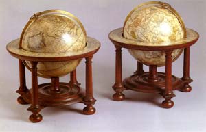
While Chambers is famous for his Cyclopaedia, Senex is perhaps most famous for his Globes, which fetch incredible prices such as the smallish 9 inch diameter pair pictured above presently for sale for the staggering price of about US$88.000 (more than twice the price of a mint first edition Cyclopaedia), however research shows that Senex globes are in fact, mainly found in museum collections and are rarely for sale, fortunately though, pictures of some excellent examples can be found at the National Maritime Museum site.
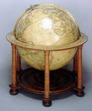
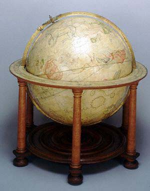
" The globes of John Senex are remarkable for their engraving and cartographic skill, and also for the knowledge of astronomy that they display. From a mechanical point of view, these are very well-made globes. The superior craftsmanship of Senex is also clear. The use of Latin on an English globe is rather unusual and could indicate that Senex intended his 680 mm (27 in) globes for the learned world, such as for professors in astronomy and geography."
Around 1724, Senex moved into Fleet Street itself, opposite St Dunstan's church. By this time, he was well-known among scholars in his field, for he published Calculation of Solar Eclipses by William Whiston, a Cambridge don and one of Newton's friends.
The basic skill of engraving could be used in different ways. Senex produced a series of plates for London almanacs, and also for Sir William Browne's Account of Microscopes and Telescopes, but from 1706, he became involved in map production. He worked first with Charles Price, and later in partnership with John Maxwell, at the Globe, in Salisbury Court, Fleet Street. In 1714, Senex and Maxwell published an English Atlas, and in 1721, A New General Atlas. Many of his maps are now in the possession of Trinity College, Dublin.
My Research
Fortunately while sifting through the internet documents I finally came across the name of Laurence Worms who seems to be about the only person in the world who has actually given a number of lectures specifically about John Senex. Mr. Worms was kind enough to forward his recent short paper on Senex to be published by Oxford University Press in the "New Dictionary of National Biography" later this year. According to Worms, Senex was "christened 24 November 1678 at Ludlow, Shropshire, the son of John Senex, gentleman, and his wife Marie. In 1695 Senex was apprenticed to the London bookseller Robert Clavell . Commencing business on his own account in 1702, first from premises in the Strand and then in Cornhill between 1703 and 1706, Senex formed an early partnership with the map-makers Jeremiah Seller and Charles Price, the successors of John Seller, a partnership also involving the manufacture and sale of navigational instruments. He continued in partnership with Price at premises off Coleman Street from 1707 to 1710, Senex then moving to Fleet Street where he remained for the rest of his life, first at the Globe in Salisbury Court (initially in partnership with John Maxwell) and from 1721 at the same sign opposite the church of St Dunstan in the West."
In his paper Worms states that Senex eventually was to become "one of the most distinguished London scientific publishers of the period", this set me off in yet another avenue of research that I had completely overlooked, which was to check the COPAC search engine of the Victoria University of Manchester.* Here I discovered hundreds of Senex related records, his publications, his maps and even some globes are on record here. I have assembled most of these entries in a time line arrangement that includes, maps, atlases, as well as his other important publications.
We can now see that Senex was not only a Globe Maker, Cartographer, Astronomer, Engraver, Bookseller, but important Publisher as well. Worms has done an excellent job of piecing together the events and people who were a major influence in the life of Senex. I had come across these details in other scattered notes however now it was becoming clear that one needs to research an number of personages in that period to get a better idea of the history of it all. First on the list might be the seventeenth-century map and instrument-maker John Seller. So I have created (here) a web page specifically to assemble notes on Seller... next I will tackle a page on Charles Price and Jeremiah Seller.
random notes
"John Senex (fl. 1690-1740) "stood at the beginning of a new branch of globe producers in Britain," in the early 18th Century (Dekker & van der Krogt, p. 112). Senex began as an astronomer and map maker, and was also an engraver, publisher, surveyor and geographer to Queen Anne. He produced pocket globes as well as larger globes in collaboration with Charles Price (fl. 1697-1733) from 1706 to 1710, and thereafter under his own name until his death in 1740. Senex's widow continued globe production until 1755. At this time the copper plates for the globe gores Senex had created were sold to James Ferguson."
from http://www.georgeglazer.com/globes/globeref/globemakers.html.
John Senex was probably first a bookseller. He was in business next to the Fleet Tavern, Cornhill, London, as a cartographer, engraver and publisher about 1700. He later traded from The Globe, Salisbury Court, Fleet Street. In 1719 he published:An Actual Survey of all the Principal Roads of England and Wales ... first performed by John Ogilby, Esq.; and now improved ...
As well as maps he produced globes. John Senex died 1740, his business was carried on by his widow Mary Senex.
Entry from "Antique maps"
"Publisher and engraver, John Senex was a contemporary of Herman Moll and no doubt, to some extent, a rival, though his output was rather smaller. In conjunction with Charles Price and James Maxwell (1708-14) he produced some fine maps of the world and the continents as well as loose maps of various countries. Apart from these he seems to have had a particular interest in road maps and in 1719 he issued a corrected edition of Ogilby's Britannia in miniature form which went through many editions.
c.1710 (with Charles Price) A New Map of Great Britain
1711 Atlas (20 maps published without title)
1712 Map of Ireland
1714 The English Atlas
1719 An actual survey of all the principal roads of England and Wales (8vo) Numerous re-issues up to c. 1775 including a French edition in 1766
1719 World and the Continents
1721 A new General Atlas of the World (small folio)
1723 Hertfordshire Re-issue of John Norden's map first published in 1593-98
Nathaniel Hill (1708-1768) was an engraver and globemaker working in London - at the Globe and Sun in Chancery Lane - who flourished from about 1730 to 1768. While Hill is interesting, as a relatively minor figure in the London map-trade, he forms part of a longer tradition of map-making than might first appear.
In 1730, Hill was apprenticed to Richard Cushee, a land-surveyor, engraver, map- and globemaker. Cushee himself had been apprenticed, in 1710, to Charles Price Sr., who was in turn apprenticed to John Seller Sr., one of the leading figures of the London map-trade in the last quarter of the seventeenth century. Cushee died in 1732, and was succeeded by E. Cushee, who is almost certainly the Elizabeth that later became Hill's wife. After the marriage, Hill took over Richard Cushee's business and shop in Chancery Lane. When Hill died, Elizabeth again took over the running of the business, for a few years. At the time Hill was apprenticed to Cushee, Cushee seems to have been working for John Senex, another leading English mapmaker. Cushee is believed to have carried out the survey work for Senex's map of Surrey, the survey completed in 1729, although the map was not published until after Cushee's death, as it bears E. Cushee's name as one of the sellers.
It would seem that, initially, Hill worked as a surveyor - a survey of Barking Marshes from 1742 is known. However, by the end of the 1740's, Hill was working principally as an engraver.
In 1747, Hill engraved William Vincent's plan of Scarborough, showing the defences of the town, raised during the Jacobite Rebellion of 1745-1746. The following year, he engraved the title and twenty-five charts for Lewis Morris' 'Plans of Harbours, Bars, Bays and Roads in St. George's Channel ...'
In 1749, Hill engraved two maps for John Warburton, Middlesex which is dated 1749, and Hertfordshire which is undated. At about the same time, Hill published a map of the country between Newcastle, to mark a proposed new route between these towns, but the map also included much information on the Roman antiquities of the region, particularly Hadrian's Wall. It is worth remarking that Warburton published a map of Northumberland in 1716, in which he included much information on Roman remains, and in 1753, Warburton published a book 'Vallum Romanum' covering much of the same ground, and Hill's map may be related to Warburton's activities.
Another more accomplished trade card (1) advertised globes of 3, 9, 12 and 15 inches (respectively 70, 230, 310 and 390mm) diameter. Sadly, in a provisional listing of British globes compiled in Richard Dunn and Helen Wallis, only examples of the 3 inch globe are recorded.
As noted above, Elizabeth Cushee continued the business for a short time after Richard's death, before one of his apprentices, Thomas Bateman succeeded to the firm. In turn, Bateman took in apprenticeship John Newton and William Palmer. Newton was to succeed his master and, under his own name, established the firm as one of the three great globe-making houses in London in the nineteenth century (with the Cary and Bardin families). William Palmer worked for a while with Newton, before establishing himself as an accomplished engraver. One of Palmer's apprentices was none other than John Cary Sr., founder of the Cary publishing house, creating an unbroken chain of descent of map and globe-making, through apprenticeships, extending from the 1670s into the 1830s.
It is often only through such tenuous strands that the trading alliances, links and careers of many such figures of the eighteenth century can be understood.Ý Much ground-breaking work on this aspect of the trade has been done by Laurence Worms, who properly identified this theme of relationship by apprenticeship.
from http://www.mapforum.com/12/12emphem.htm.*
Charles Price, John Senex and John Maxwell collaborated from about 1708 to 1714 producing separately issued maps of the world, the continents and individual countries. Price was a surveyor and mapmaker, whose maps were nearly all collaborative efforts. After his association with Senex, he worked with Jeremiah Seller and later George Willdey. Senex was a publisher and engraver, who made maps in a modified Dutch style. He was Geographer to Queen Anne, and he was elected to the Royal Academy in 1728. Cartographical works by Senex appear as late as 1746. John Maxwell was also a Geographer to Queen Anne, but he is known only in connection with Price and Senex, and there do not appear to be maps bearing his name after 1712.
from http://www.donaldheald.com/maps/maps_detail_01.php?cat=Europe&itemnr=1222170.
Celestial miniature globe. It forms a pair with the terrestrial globe, Senex GLB0034. Astronomical details on the sphere are the same as Price and Senex GLB0013. There is a labelled magnitude table in front of Ursa Major, and 22 stars and three star groups are named. The 48 Ptolemaic constellations and two of the non-Ptolemaic constellations are drawn. There are two of the southern constellations, as well as those of Plancius and one of Hevelius.
The gores of the Senex 70 mm (2.75 in) celestial globe are identical to those of the pocket globe first issued by Price and Senex as partners. Senex had new gores for his terrestrial globe, using the terrestrial pocket globe he produced with Price only as an example. This copy must be a later edition, because other recorded copies have California depicted as an island and do not include Anson's track. These two revisions are often incorrectly assumed to have been introduced by George Adams, who acquired the copper plates in circa 1756, but the present globe demonstrates that they were made by Senex. The later editions by Adams can be distinguished from the present one because they show in addition, a hypothetical eastern coast of Australia - see Adams GLB0014 and GLB0052.
from http://www.nmm.ac.uk
* "COPAC is a union catalogue. It provides FREE access to the merged online catalogues of 24 of the largest university research libraries in the UK and Ireland PLUS the British Library & the National Library of Scotland."
do you have something informative to add to this page??? Please contact me!
| see more Chambers's CYCLOPAEDIAS | Go to Paradise Islands |